
Voyage Planning Tips
Consultation for Your Inside Passage and Southeast Alaska Voyage
The Pacific Northwest offers unbeatable cruising along the Inside Passage. That's because you can travel on your own boat (or a chartered vessel) in protected waters all the way up through British Columbia (Desolation Sound, the Broughton Islands) to Southeast Alaska.
Daunting? It doesn't have to be. If you have the boating skills, you just need some inside information for the skipper and the crew to make this passage.
discuss Voyage Planning consultation services with Captain Linda Lewis. Topics you may be interested in include:
- Trip planning based on your available time and adventuring spirit (See an example of a glacier adventure below)
- Specific route recommendations and local knowledge
- Strategies for transiting specific tidal narrows in British Columbia and Southeast Alaska
- Weather information
- SE Alaska Docking Etiquette and Anchoring tips
- General considerations, such as: customs, provisioning, communications, fuel, and clothing
- Southeast Alaska's charts should be used cautiously. See below for an example of a chart inaccuracy in Southeast Alaska's Gut Bay, on Baranof Island
- Uncharted rocks also pose problems. See below for a bit of local knowledge on the uncharted rock in Kalinin Bay, north of Sitka
If you need to brush up on your boat handling, navigation, radar, or other boat handling skills before you go, contact Capt. Linda Lewis.
A SMOOTH SEYMOUR NARROWS TRANSIT
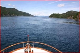
One of the top questions I get from boaters who want to cruise the Inside Passage is: "How do I navigate safely through the tidal narrows?"
The answer to that is especially important for a place called Seymour Narrows, in British Columbia.
At peak flow it can run up to 15 knots.
Doesn't look too bad, does it?
That's because we're not there at peak flow.
We're there at slack water.
That's when you should go.
That's the key to a safe tidal-narrows transit.

This is what you should look like going through any tidal narrows.
If you feel like yawning your way through the narrows, it means you timed slack water correctly.
What's the uproar about?
Plenty.
You need to have great respect for tidal narrows.
Learn how to determine the time of slack water. Do that and you will get through them safely.

Here is a tame version of what you might encounter if your timing is off.
Go at slack water, like the first picture.
Be smart.
Record yourself yawning.

Dodd Narrows is another challenging spot in British Columbia.
It is short and narrow.
And you can't see the oncoming traffic that may be right around the corner.
Did I say traffic? That is the really tricky part.
There is usually a fair amount of it.
Vessels speeding through throw up a wake that strikes the shore and reverberates back to your boat.
Take care. Go at slack.

This photo shows Dodd about 30 minutes before slack.
The picture speaks for itself.
Even if you are a fast boat, calculate your timing carefully and go at slack. Leave the heroics to someone else.
A Sawyer Glacier adventure

Sawyer Glacier is just one of the many adventures in Southeast Alaska you shouldn't miss.
This is an icy dinghy ride in Tracy Arm, Southeast Alaska. That's the South Sawyer Glacier in the distance.
The ice pack prevented me from going any closer in my 45' trawler-style powerboat. So I hopped in the dinghy and dodged the chunks of ice - called bergie bits - that fall off the glaciers.
Gut Bay - chart inaccuracy

Here is an example of a chart inaccuracy in Southeast Alaska.
Gut Bay is located on the east side of Baranof Island. It was surveyed in 1897 and they just didn't get it right.
The black line is my charted course. The red line is my GPS 'crumb trail' (track line) as I entered the bay.
I obviously didn't portage that peninsula. Nor did I anchor on the hillside.
The GPS is accurate. The chart is not. Nothing takes the place of looking out the window. That's how I got in there safely. Practice situational awareness - always.
Still with me? Let's look at an uncharted rock in Kalinin Bay.
Kalinin Bay - uncharted rock

Kalinin Bay is a convenient anchorage for those who have just passed through Sergius Narrows (in Peril Strait) and are on their way to Sitka.
However, this bay harbors an uncharted rock. The Douglass guide book Exploring Southeast Alaska (2007) warns of this rock. I wanted to know exactly where it was.
Here is what I found when I went looking for it in my dinghy on a minus tide.
In the screen shot to the right it is noted as a black plus sign with four dots, surrounded by a dotted circle. The uncharted rock was lying primarily in a NE/SW axis and was two feet under my dinghy on this minus 2.8 foot tide.
I recorded the uncharted rock at:
57° 19.483'
135° 47.082'
In 2008, the U.S. Coast Pilot (2008) added a latitude/longitude for this rock. (Note the Coast Pilot provides the data in minutes and seconds, while your GPS displays in tenths/hundredths of a minute.)